


In Brief: The Texas Floods and Land Use Regulation
Why are RV parks and camp cabins in the floodplain?

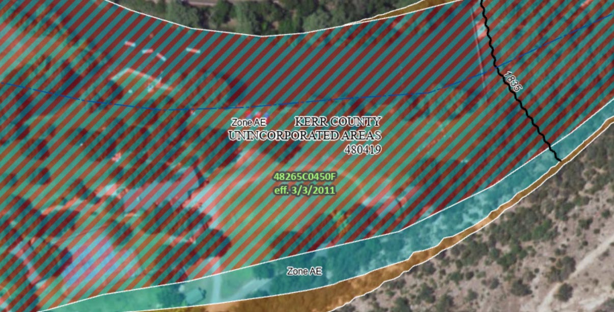
The unspeakable tragedy of the Texas Hill Country floods highlights an underappreciated source of vulnerability in many small towns and rural communities: the location of low-cost and irregular housing in high-hazard areas like floodplains. The Hill Country floods swept away numerous RV and mobile home parks and killed at least 27 children at a sleep-away camp on the Guadalupe River when their cabins were destroyed by swift water. A cursory analysis of the flood insurance rate maps for the county shows that many of these sites were located in regulatory floodplains and even floodways (see also this piece from the Washington Post).
How can this happen? With all we know about disaster risk, why are some of our most vulnerable populations - like children, tourists, and indigent residents of mobile home parks - located in such hazardous geographies? And why haven’t land-use regulations corrected the issue?
A few brief thoughts on a complex question and topic:
Historically many low-value land uses (like mobile home parks) were located in floodplains, by virtue of market dynamics (flood-prone land is cheap and profitable to rent to mobile home owners) and because of discriminatory land use policies. Later these uses were often limited to places where they already existed, e.g. floodplains. So across Texas and the United States, researchers have found that mobile home parks, RV parks, and other precarious housing types are locked into hazard and climate exposure, with limited options for adaptation or resiliency.
In decades past, mobile homes (those built before 1976) were assumed to be transportable. In reality, the vast majority of mobile homes never moved and today are likely impossible to move without causing irreparable damage. Newer manufactured homes are still built on a steel chassis to ensure “ongoing transportability,” but in-reality are rarely moved and can’t be without significant logistical support and homeowner expense. In many jurisdictions land use regulations have not caught up to these realities.
Floodplain development regulations, which local governments are required to adopt to participate in the National Flood Insurance Program, generally have much stricter requirements for permanent uses than for temporary ones. So while a developer might be required to elevate a new home above the base flood elevation or avoid the floodway, a temporary use like an RV park or summer camp might be allowable. Local jurisdictions are free to adopt higher standards than FEMA requires, but rarely do - especially small and rural jurisdictions with limited capacity (or appetite) to regulate.
We give the vast majority of land use authority to local governments in the United States, and even those that adopt disaster- and climate-smart land use codes have only limited ability to address existing vulnerabilities. In Texas, county governments have limited land-use authority that does NOT include zoning (i.e. counties cannot adopt zoning ordinances). They can, however, adopt land use regulations that aim to minimize losses from flooding. In fact Kerr County, where Camp Mystic is located, adopted a flood damage prevention order in 2020 that requires residential construction (including manufactured homes) to be built in ways that reduce the risk of damage and loss of life. These regulations only apply to new development and substantial redevelopment of existing structures, however, meaning that development from before 2020 is ‘grandfathered.’ So while the camp cabins that were swept away in Texas probably couldn’t be rebuilt under the contemporary regulations, the harm is already done.
Further, many small jurisdictions adopt minimum standard floodplain regulations that are not often crafted to match their geographic or hazard context. For example, my brief read of the Kerr County prevention order is that RV parks are allowable in some flood-prone areas under specific conditions, like being occupied for less than 180 days per year and that each RV is operable. Yet the Hill Country floods occurred in a matter of hours. Realistically could dozens of RVs be made ready and driven off-site before the flash flood swept them away? Are RVs ever an appropriate use in a Hill Country floodplain context?
Taking a step back and thinking about the larger research and policy picture, how many people sleep each night in housing deemed temporary by local land use regulations, and what share of those temporary units are in hazardous areas? How does the temporality of that housing align with the seasonality of certain hazards like flash floods and wildfires? And what share of those housing units are grandfathered from contemporary land use regulations? These are vital questions that no one (to my knowledge) has answered, but are essential to crafting good policy. This as scientific funding for disaster and climate research is being gutted.
Sorry I missed this valuable piece on land-use policy and risk reduction before posting on related issues on Sustain What. Just added a link here! https://revkin.substack.com/p/closing-the-deadly-last-mile-gap
Hi Andrew, Have you heard of anyone reverse engineering Afflux design for bridges and causeways to slow and temporally retard the flood? The science behind flooding points to two areas of relevance friction vs slope and infiltration.
In regards to friction several options may be available, mass plantings of trees which may or may not be high coppiced for longevity vs shade
Each road structure offers opportunity for retardation and slowing the flow, causeways could have concrete barricades and the causeway concrete can control the erosional fall of water.
Small bridges can be caged with the intention for a leaky weir structure up to a certain height
Large freeways can be double tiered where one is lower than the other to intentionally cause an obstruction and the upper can be dual way while in flood.
With redevelopment these can be raised and levees added to retard the flood over much larger areas upstream especially where interlocking spurs allow for a natural choke point. All this allows for longer response times and damage minimization
.
On the flat lands in the Australian outback on method of infiltration that is being trialed on the vast flat flood plains of the interior is the spreader levee, where water is retarded in the creek by either siltation mesh on a braced fence, or physical barrier of debris then a levee is used once the creek is breached to spread the flood over as wide an area as slope allows for it to soak in. They are currently trialing projects in the order of 250 000 acres or more to great success. These control floods but most importantly control erosion and allow for these intermittent hard flood events to rehydrate vast areas of semi arid land.